
An Aerial View of the Dragon

An Aerial View of the Dragon
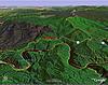
I used Google Earth to make this aerial "photo" of the Dragon on US129. The view is looking to the northeast from an altitude of ~12000 ft. The Dragon goes from NC (on the right) into TN (left). Rt 28 (going to the Fontana) and 129 meet at the right. Enjoy ! 


6th Gear
Joined: May 2003
Posts: 1,395
Likes: 0
From: Virginia Beach, Virginia
also check out http://local.live.com/
there is an aerial function that works for the Deals Gap area.
(in some places like LA or NY/eastern seaboard there is a very cool "birds eye" feature available)
there is an aerial function that works for the Deals Gap area.
(in some places like LA or NY/eastern seaboard there is a very cool "birds eye" feature available)
Originally Posted by BartMack
also check out http://local.live.com/
there is an aerial function that works for the Deals Gap area.
(in some places like LA or NY/eastern seaboard there is a very cool "birds eye" feature available)
there is an aerial function that works for the Deals Gap area.
(in some places like LA or NY/eastern seaboard there is a very cool "birds eye" feature available)
If you want to see the Dragon on "Live", click here. I put point 1 at the "Crossroads of Time" at the intersection of NC28 & US129, and 2 is at one of the normal turnaround points.
With "Live" it is fairly easy to zoom in on the actual road and then "drive" it with your mouse. Most of the turns 'n twisties are reproduced fairly failthfully. Google Earth tend to use short straigh-line segments.
I would have sent the corresponding Google Earth pushpins, but NAM does not permit the .KMZ pushpin file types.

Thread
Thread Starter
Forum
Replies
Last Post
Mini Mania
Vendor Announcements
0
Sep 25, 2015 12:32 PM
midnightblackjcw
JCW Garage
0
Sep 21, 2015 10:58 AM